Hurricane Ike made landfall at Galveston, Texas at 2:10 a.m. this morning. Maximum sustained winds were 110 miles per hour, just one mph less than a Category 3 strom. High surge, wind, heavy rains, tornadoes, widespread flooding, massive power outages, and fires were the main news stories overnight.
As many as 1200 calls for rescue were received from people who did not evacuate. Most were told they would have to wait until conditions improved. Officials are trying to get out to complete rescues, as well as, to assess the damage. Of particular concern is the status of the oil and chemical plants, and the skyscrapers in downtown Houston.
As you can see from radar, Ike is still dealing a heavy punch to the area this morning. As of the 8:00 a.m. CDT advisory, it was a Category 1 storm with maximum sustained winds near 90 mph. Additional weakening is expected throughout the day, but Ike could remain a hurricane into this afternoon. Hurricane force winds extend out 125 miles, with tropical storm force up to 260 miles. Although not as powerful of a storm, Ike had a larger wind field than Katrina.
Ike will be making a turn to the northeast sometime later today. This will take the storm to areas of the midwest that are already soaked from heavy rains due to a stalled front. Ike will meet up with a cold front and bring additional heavy rains.
Obviously, all of the TV news stations will be bringing more information and videos as it becomes available. This will be my last report on Ike. Thank you for reading.
Residents along the upper-Coast of Texas and western Louisiana can’t do much more but finish preparations and wait for the worst part of Ike. Ike remains a large storm with hurricane force winds extending out 120 miles and tropical storm force winds up to 275 miles.
They are already starting to feel the effects. Water levels, winds, and waves are on the rise. As much as 20 foot of storm surge along with large and battering waves are expected. Waves and water are already covering roadways, even though landfall is still approximately 12 hours away. Southwest Louisiana already has a storm surge of over 9 ft; over 6 ft. in Galveston. The buoy 22 NM east of Galveston is recording 19 ft. waves.
In the local area, things are still trying to calm and are getting better as time goes by. Things should be back to normal by the weekend.
Other Ike Pics: Here are some photos that were sent to me by Jan Nonog. Jan wrote, “These were taken yesterday evening around 4.30pm to 5 at Tyndall AFB Beach. The whole beach was flooded right back to the boardwalk, normally it takes 2 or 3 minutes to walk to the water from there.” Thank you Jan for sharing!!
As of the 4:00 pm CDT advisory from the National Hurricane Center, the center of Ike is about 400 miles ESE of Galveston, Texas. The center is expected to reach the upper-Texas coast by late Friday. Coastal storm surge of more than 20 feet is expected near and to east of where the center makes landfall. In addition, as much as 15 inches of rain is forecasted for some areas.
Hopefully, all people in the area are securing their property and evacuating. Galveston, the site of the U.S.’s worst Hurricane death toll, is especially vulnerable to coastal flooding and erosion. It is a beautiful coastal town which some are betting will become the “Long Island of Texas”. The downtown area has many old Victorian homes and buildings that have stood the test of time.
The coast of Galveston is very similiar to the Atlantic coast of Florida. The houses sit far back from the water at a higher elevation from the beach. This creates a serious problem where the earth under houses erode quite significantly. To help the problem, many use a product called a Geo-Tube, which is a essentially a very long, and very tall, sand bag. The Geo-Tube is buried in the ground to protect from washout.
In the local area, the Gulf appears to be calming somewhat as we approach low tide. It will be a few days before things get back to normal. Hopefully, when the water recedes back to its normal level, our beach will build back easily. Only time will tell.
With Ike in the Gulf, our seas are very rough. Offshore, swells are exceeding 25 feet with seas 8 to 12 feet in shore. Seas aren’t expected to come down until Sunday.
I was at Treasure Island Condominiums earlier and there is no beach between the building and the water. The surf is crashing up against the building and lapping at the pilings of beach homes. After Gustov, we had a little erosion, but we were told at the TDC meeting Tuesday that it would build back naturally. We’ll see after this system moves through. The dock by my house was almost completely covered and boats at a local marina are looking a little high.
Stay tuned to pcbdaily.com for all updates for Hurricane Ike.
I don’t know what these two were thinking. I saw them enter the water near the Rick Seltzer Park. They tried very hard to make it out, but couldn’t even get past the first breaking surf line. It didn’t take much time at all and they were already out of the water. It looked like they had enough and were calling it a day.
See, even locals can make some bad judgments at times. Well, who could blame them.
Do you know it is only a single red flag day?
Other pictures:
Anyone from the area who has some interesting pics, send them to me at cdurta@att.net. I would like to get some from the other areas around the county.
Well, it is 6 a.m., which is right about high tide. I am awakened to the roar of the waves and can tell without even looking that the situation has changed significantly overnight. It is still a bit dark, but from what I can see the water is covering most of the beach and moving fast. It appears that some has even come passed our fence line and into our “yard”. The surf is very rough. The buoy south of Panama City that I reported as recording 10 feet wave heights yesterday, is now showing over 24 feet.
The 4 a.m. advisory from the National Hurricance Center read in part,
AT 400 AM CDT…0900Z…THE CENTER OF HURRICANE IKE WAS LOCATED NEAR LATITUDE 25.2 NORTH…LONGITUDE 87.6 WEST OR ABOUT 620 MILES…995 KM…EAST OF BROWNSVILLE TEXAS AND ABOUT 285 MILES…460 KM… SOUTH-SOUTHEAST OF THE MOUTH OF THE MISSISSIPPI RIVER.
IKE IS MOVING TOWARD THE WEST-NORTHWEST NEAR 9 MPH…15 KM/HR. A GENERAL WEST-NORTHWESTWARD MOTION OVER THE CENTRAL AND WESTERN GULF OF MEXICO IS EXPECTED TODAY AND FRIDAY. ON THIS TRACK THE CENTER WILL BE APPROACHING THE NORTHWESTERN GULF OF MEXICO COAST LATE FRIDAY.
MAXIMUM SUSTAINED WINDS ARE NEAR 100 MPH…160 KM/HR…WITH HIGHER GUSTS. IKE IS A CATEGORY TWO HURRICANE ON THE SAFFIR-SIMPSON SCALE…AND IT COULD INTENSIFY INTO A CATEGORY THREE HURRICANE OVER THE NEXT DAY OR TWO.
IKE IS A LARGE TROPICAL CYCLONE. HURRICANE FORCE WINDS EXTEND OUTWARD UP TO 115 MILES…185 KM…FROM THE CENTER…AND TROPICAL STORM FORCE WINDS EXTEND OUTWARD UP TO 255 MILES…410 KM.
AN AIR FORCE HURRICANE HUNTER PLANE REPORTED A MINIMUM CENTRAL PRESSURE OF 946 MB…27.94 INCHES.
COASTAL STORM SURGE FLOODING OF 3 TO 5 FEET ABOVE NORMAL TIDE LEVELS…ALONG WITH LARGE AND DANGEROUS BATTERING WAVES…CAN BE EXPECTED WITHIN THE TROPICAL STORM WARNING AREA. ABOVE NORMAL TIDES OF 2 TO 4 FEET ARE EXPECTED ELSEWHERE ALONG MUCH OF THE NORTHERN COAST OF THE GULF OF MEXICO DURING THE NEXT DAY OR SO…BUT WILL BE INCREASING ALONG THE WESTERN GULF COAST AS IKE APPROACHES.
As Ike makes his way across the Gulf, the coastal waters off Panama City Beach are already starting to swell. Surf conditions are expected to rapidly deteriorate throughout the day today and into tomorrow. This has prompted the National Weather Service to issue advisories to coastal and marine interests.
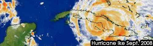
Satellite Image of Ike This Morning
As of the 11a.m. EDT advisory, Ike was a Category 1 storm with maximum sustained winds near 90mph with higher gusts. Ike is a large tropical cyclone. Hurricane force winds extended outward up to 80 miles from the center and tropical storm force winds out up to 205 miles. A gradual increase in strength is expected as Ike moves over the loop current and other warm eddies. The official forecast from the National Hurricane Center is for Ike to become a category 3 storm.
In our area, rain and windy conditions should begin tonight and continue to Friday. Tropical storm conditions are not expected, although gusts may reach that level in rain bands. Severe weather is also not expected.
Coastal Flood Watch
A Coastal Flood Watch is in effect for the Florida Panhandle and Big Bend immediate coasts from the Suwannee River Entrance westward to Destin for Wednesday evening to Thursday evening. Below is an excerpt from the statement:
STRONG EAST TO SOUTHEASTERLY WINDS OF 20 TO 25 MPH WITH HIGHER GUSTS WILL PUSH WATER INTO THE COASTLINE BEGINNING WEDNESDAY EVENING. THIS RISING WATER COMBINING WITH HIGH ASTRONOMICAL TIDES WILL LIKELY PRODUCE A PERIOD OF COASTAL FLOODING ALL ALONG THE COAST. THE EFFECT OF THIS FLOODING WILL BE MAXIMIZED AROUND THE TIME OF HIGH TIDE. AREAS PREVIOUSLY IMPACTED BY HURRICANE GUSTAV WILL BE ESPECIALLY VULNERABLE TO COASTAL FLOODING AND BEACH EROSION.
AT THIS TIME…AREAS FROM THE AUCILLA RIVER TO THE SUWANNEE RIVER ENTRANCE CAN EXPECT STORM TIDE VALUES…WHICH IS THE HEIGHT ABOVE MEAN LOWER LOW WATER…OF 3 TO 5 FEET AROUND HIGH TIDE ON WEDNESDAY NIGHT AND THURSDAY.
AREAS FROM CAPE SAN BLAS TO SAINT MARKS CAN EXPECT STORM TIDE VALUES BETWEEN 4 TO 7 FEET AROUND THE HIGH TIDE ON WEDNESDAY NIGHT AND THURSDAY.
AREAS FROM DESTIN TO MEXICO BEACH CAN EXPECT STORM TIDE VALUES BETWEEN 2 TO 4 FEET AROUND HIGH TIDE ON WEDNESDAY NIGHT AND THURSDAY.
BELOW ARE TIMES OF HIGH TIDE AND LOW TIDE AT SELECTED LOCATIONS ALONG THE FLORIDA PANHANDLE AND BIG BEND COASTLINES…
SUWANNEE RIVER ENTRANCE…HIGH TIDE 1248 AM THURSDAY…LOW TIDE 555 AM THURSDAY…HIGH TIDE 1135 AM THURSDAY.
SHELL POINT…HIGH TIDE 115 AM THURSDAY…LOW TIDE 620 AM THURSDAY…HIGH TIDE 1227 AM THURSDAY.
SAINT GEORGE ISLAND…HIGH TIDE 138 AM THURSDAY…LOW TIDE 513 AM THURSDAY…HIGH TIDE 1042 AM THURSDAY.
NOTE THAT THE LOW TIDE AMPLITUDE AT THESE THREE SITES IS ONLY AROUND HALF A FOOT LOWER THAN THE HIGH TIDE. THIS MAY LEAD TO A PROLONGED PERIOD OF INUNDATION IN LOW LYING AREAS ALONG THE COAST.
AT PANAMA CITY…HIGH TIDE 611 AM THURSDAY…LOW TIDE 425 PM THURSDAY.
AT DESTIN…HIGH TIDE 755 AM THURSDAY…LOW TIDE 637 PM THURSDAY.
HIGH SURF OF 9 TO 13 FEET…WITH HIGHER SETS UP TO 15 FEET WILL BE POSSIBLE WEDNESDAY NIGHT THROUGH FRIDAY ALONG THE FLORIDA PANHANDLE COAST FROM DESTIN TO SAINT GEORGE ISLAND IN FRANKLIN COUNTY. MUCH LOWER SURF HEIGHTS OF 3 TO 6 FEET ARE EXPECTED EAST OF SAINT GEORGE ISLAND TO ALLIGATOR POINT.
A COASTAL FLOOD WATCH MEANS THAT CONDITIONS FAVORABLE FOR COASTAL FLOODING ARE EXPECTED TO DEVELOP. COASTAL RESIDENTS SHOULD BE ALERT FOR LATER STATEMENTS OR ARNINGS…AND TAKE ACTION TO PROTECT PROPERTY.
Small Craft Advisory
A Small Craft Advisory is effect from 8 a.m. EDT this morning through Saturday afternoon. The forecast is as follows:
COASTAL WATERS FROM APALACHICOLA TO DESTIN FL OUT 20 NM- COASTAL WATERS FROM OCHLOCKONEE RIVER TO APALACHICOLA FL OUT TO 20 NM-
TODAY
EAST WINDS 15 TO 20 KNOTS. SEAS BUILDING TO 4 TO 6 FEET ALONG THE COAST…6 TO 9 FEET OFFSHORE. PROTECTED WATERS CHOPPY. NUMEROUS SHOWERS AND THUNDERSTORMS.
TONIGHT
EAST WINDS 15 TO 20 KNOTS…BECOMING SOUTHEAST AND INCREASING TO 20 TO 25 KNOTS AFTER MIDNIGHT. SEAS BUILDING TO 6 TO 9 FEET ALONG THE COAST…9 TO 12 FEET OFFSHORE. PROTECTED WATERS CHOPPY…INCREASING TO ROUGH AFTER MIDNIGHT. SCATTERED SHOWERS AND THUNDERSTORMS.
THURSDAY
SOUTHEAST WINDS 20 TO 25 KNOTS…DECREASING TO 15 TO 20 KNOTS IN THE AFTERNOON. SEAS 7 TO 9 FEET ALONG THE COAST…9 TO 12 FEET OFFSHORE. PROTECTED WATERS OUGH…DECREASING TO CHOPPY IN THE AFTERNOON. NUMEROUS SHOWERS AND THUNDERSTORMS.
THURSDAY NIGHT
SOUTHEAST WINDS 15 TO 20 KNOTS. SEAS 6 TO 8 ALONG THE COAST…8 TO 11 FEET OFFSHORE. PROTECTED WATERS CHOPPY. SCATTERED SHOWERS AND THUNDERSTORMS.
FRIDAY
SOUTHEAST WINDS 15 TO 20 KNOTS…DECREASING TO 10 TO 15 KNOTS IN THE AFTERNOON. SEAS 5 TO 7 FEET ALONG THE COAST…7 TO 9 FEET OFFSHORE. PROTECTED WATERS CHOPPY…DECREASING TO A LIGHT TO MODERATE CHOP IN THE AFTERNOON. SCATTERED SHOWERS AND THUNDERSTORMS.
FRIDAY NIGHT
EAST WINDS AROUND 10 KNOTS. SEAS 5 TO 7 FEET. PROTECTED WATERS A LIGHT CHOP. ISOLATED SHOWERS AND THUNDERSTORMS.
SATURDAY
SOUTHEAST WINDS 5 TO 10 KNOTS. SEAS 5 TO 7 FEET…SUBSIDING TO 4 TO 6 FEET IN THE AFTERNOON. PROTECTED
WATERS SMOOTH TO A LIGHT CHOP.
Current readings from the buoy 115NM ESE of Pensacola (28°47’28” N 86°0’29” W)are reporting wave heights of approximately 10.2 feet with wind gusts to 25.3 kts.
Hurricane Ike, barely a Category 1 storm, is still working its way across Cuba. Ike is forecast to enter the Gulf of Mexico within 24 hours. The track guidance has shifted towards mid to southern Texas as it is believed that the steering patterns will cause the system to move on a more westerly track. Once over the Gulf, Ike is expected to restrengthen to a Category 2 storm.
As of the 11 a.m. advisory, the National Hurricane Center (NHC) track was as follows:
So, what are the expected ramifications for Panama City Beach? The Hazardous Weather Outlook issued by the National Weather Service Tallahassee this morning stated the following in part:
WEDNESDAY THROUGH MONDAY…
HURRICANE IKE IS FORECAST TO MOVE WEST-NORTHWEST ACROSS THE
SOUTHERN AND CENTRAL GULF OF MEXICO OVER THE NEXT SEVERAL DAYS.
A MOIST SOUTHEASTERLY FLOW AROUND IKE WILL INCREASE THE CHANCES
FOR SHOWERS AND THUNDERSTORMS WEDNESDAY AND THURSDAY.
A FEW STORMS COULD BE STRONG AND GENERATE LOCALLY HEAVY RAINFALL.
HOWEVER…WIDESPREAD SEVERE WEATHER IS NOT ANTICIPATED AT THIS
TIME.
ALONG THE COAST…EAST TO SOUTHEAST FLOW WILL INCREASE OVER THE
NEXT SEVERAL DAYS BRINGING SMALL CRAFT ADVISORY CONDITIONS TO THE
COASTAL WATERS. IN ADDITION…LARGE SWELLS FROM IKE WILL APPROACH
THE COAST STARTING LATE WEDNESDAY AND CONTINUING THROUGH THE END
OF THE WEEK. THE COMBINATION OF SOUTHEAST WINDS…LARGE
SWELLS…AND HIGH ASTRONOMICAL TIDES DUE TO AN APPROACHING FULL
MOON…MAY LEAD TO SOME MINOR BEACH EROSION AND MINOR COASTAL
FLOODING AT TIMES OF HIGH TIDES BY LATE WEDNESDAY AND CONTINUING
INTO FRIDAY.
THE LARGE SWELLS FROM IKE ARE ALSO LIKELY TO GENERATE DANGEROUS
SURF AND RIP CURRENTS ALONG AREA BEACHES BY WEDNESDAY AFTERNOON.
SURF CONDITIONS ARE EXPECTED TO BECOME LIFE THREATENING FOR ANYONE
ENTERING THE WATER FOR THE SECOND HALF OF THE WEEK.
The Marine Forcast for the coastal waters from Apalachicola to Destin out 20 NM is:
IKE IS EXPECTED TO EMERGE INTO THE SOUTHEASTERN GULF OF MEXICO LATER TODAY. THE WINDS AND SEAS WILL STEADILY INCREASE ACROSS THE MARINE AREA THROUGH THURSDAY. AT THIS TIME…WINDS ARE EXPECTED TO REMAIN BELOW TROPICAL STORM FORCE. HOWEVER…SIGNIFICANT SWELLS GENERATED BY IKE WILL BE MOVING INTO THE WATERS BY LATE WEDNESDAY INTO FRIDAY.
WEDNESDAY EAST WINDS 15 TO 20 KNOTS. SEAS 3 TO 5 FEET.
PROTECTED WATERS CHOPPY. SHOWERS AND THUNDERSTORMS LIKELY.
WEDNESDAY NIGHT EAST WINDS 20 KNOTS. SEAS 6 TO 8 FEET…SOME SWELL.
PROTECTED WATERS CHOPPY. A CHANCE OF SHOWERS AND THUNDERSTORMS.
THURSDAY SOUTHEAST WINDS 20 KNOTS. SEAS 8 TO 10 FEET…SOME
SWELL. PROTECTED WATERS CHOPPY. SHOWERS AND THUNDERSTORMS LIKELY.
THURSDAY NIGHT EAST WINDS 15 KNOTS. SEAS 9 TO 11 FEET…MAINLY
SWELL. PROTECTED WATERS A MODERATE CHOP. A CHANCE OF SHOWERS AND
THUNDERSTORMS.
FRIDAY SOUTHEAST WINDS 10 TO 15 KNOTS. SEAS 8 TO 10
FEET…MAINLY SWELL. PROTECTED WATERS A LIGHT TO MODERATE CHOP. A
CHANCE OF SHOWERS AND THUNDERSTORMS.
FRIDAY NIGHT EAST WINDS 5 TO 10 KNOTS. SEAS 6 TO 8
FEET…MAINLY SWELL. PROTECTED WATERS SMOOTH. A SLIGHT CHANCE OF
SHOWERS AND THUNDERSTORMS.
SATURDAY SOUTHEAST WINDS 5 TO 10 KNOTS. SEAS 5 TO 7
FEET…MAINLY SWELL. PROTECTED WATERS SMOOTH. A CHANCE OF SHOWERS
AND THUNDERSTORMS.
Based on this I would advise anyone wanting to go to the beach or take the boat out to do so pronto. Besides, the water is pristine right now. Thanks to Gustav most of the seaweed has been cleared. The other day it was so clear along the shore you could see the crabs running. Days like this don’t happen all that often. So my advice is to get out today before things get churned up.
Greetings from the new Weather Girl. Starting today, I will be writing weather updates for pcbdaily. Although I am not a meterologist, forecaster, or scientist, I love learning about the weather. Since moving to Panama City Beach I have become very interested in tropical systems. I spend a great deal of my time tracking storms and researching data. I also have the Weather Channel on so much that my family makes fun of me. So, I guess what I’m trying to say is that everyone is hereby put on notice that I am just an uneducated weather geek, so any future postings by me should not be considered an official weather forecast.
My goal is to summarize and combine a lot of the information that is out there. I have a routine of gathering data from several different websites and I wish it were all in one place. When reporting on systems I will try to provide information from the National Hurricane Center, NOAA, Navy Weather Sites, the National Weather Service, and other prominent weather agencies. The format will change depending on the circumstances and what information is available.
If anyone out there has suggestions or would like to see information from certain sources please let me know. There is so much data available and it is hard to figure out what is most important. I encourage those with knowledge on the subject to contribute to, or correct, anything I write.
Hurricane Ike has slowed as it has traveled over Cuba, but is expected to regain some strength in the Gulf of Mexico.
Currently a category 2 hurricane with winds at 100 mph, this storm is moving fast at a sweeping 14 mph west-slightly-north. The current track is pointing it directly at Houston.
As reported on weather.com:
Hurricane Ike made landfall around 9:45 p.m. EDT Sunday evening, near Punto De Sama in the Cuban province of Hoguin with winds estimated near 125 miles per hour.
As of 11 a.m. EDT today, Ike was located about 45 miles WSW of Camaguey, Cuba, and moving westward at 14 mph. Due to being over land for the last 12 hours or so, Ike has weakened to a Category 2 hurricane with winds near 100 mph. Some slight strengthening may occur today since it appears the center of Ike will move into the Caribbean Sea shortly, then turn west-northwestward, skirting the south Cuban coast.
Hurricane warnings are posted for much of Cuba. A hurricane watch is in effect for the Florida Keys. A tropical storm warning is in effect for Andros Island in the Bahamas, the Little Cayman and Cayman Brac in the Caribbean, and the Florida Keys. A tropical storm watch is posted for Grand Cayman and Jamaica.
Ike will continue to unleash heavy rains on Cuba with life-threatening flash floods and mudslides a distinct possibility.
After battering Cuba, Ike is forecast to swirl into the southeast Gulf of Mexico late Tuesday or early Wednesday and in all probability, re-strengthen. Its course after that point remains uncertain, but residents all along the U. S. Gulf Coast from Texas to Florida should stay apprised of this dangerous storm.

 Hurricane Ike made landfall at Galveston, Texas at 2:10 a.m. this morning. Maximum sustained winds were 110 miles per hour, just one mph less than a Category 3 strom. High surge, wind, heavy rains, tornadoes, widespread flooding, massive power outages, and fires were the main news stories overnight.


